History
 |
Newfoundland History |
 |
[This text was written in 1950. For the full citation, see the end of the text. Parts in brackets [...], images and links have been added by Claude Bélanger.]
Position and structure.
The large island of Newfoundland lies off the east coast of North America between latitudes 46½°N and 52°N. Its capital, St. John's, is in the same latitude (47½°) as Quebec, Duluth, Seattle, Paris, and Sakhalin island in the Pacific; but owing to its oceanic environment the latter region is its sole homoclime. Newfoundland is triangular in shape, about 320 miles across, and occupies an area of 43,000 square miles. It is thus about the size of Pennsylvania, and is much larger than Ireland. It lies on the continental shelf of North America, being separated from Labrador by only 11 miles, and from Cape Breton by 70 miles. In geology and structure it is more closely linked with Nova Scotia than with the great area of undulating ancient granites (known as the Shield) in eastern Canada.
The structure or build of Newfoundland is probably the chief factor in determining the remarkable distribution of settlement in the island. Although settlement was begun more than 300 years ago it is still almost wholly confined to the coasts, except in two small areas near Grand Falls and Deer Lake. This situation may be ascribed to the fact that the island is plateau-like, with steep shores on all sides except the northeast.
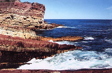
Rugged coast of Newfoundland, King's Cove
(Photo courtesy of Kent Hotson)
Along the west coast is an elongated block of the earth's crust (called a horst) much of which rises to nearly 2,000 feet above sea level. This is called Long Range on current maps, and it is probably bounded by crustal cracks (faults) on both west and east sides. Somewhat to the east is a fairly wide depression containing Grand Lake and Deer Lake. It is some 20 miles wide, and probably is due to a block of the crust dropping down to form the Grand Lake graben (depression). Not much is known of the geology of the interior, but perhaps Red Indian Lake occupies another shallower graben, since its axis follows the same direction as does Grand Lake. The plateau level descends gradually to the east and north-east, as the section shows. Trinity and Conception bays probably occupy similar grabens, while in the Avalon peninsula the plateau level has sunk to 800 feet or less.
This plateau, with a general level of about 1,200 feet, includes a large part of Newfoundland. It is an elevated peneplain; that is, it has been elevated above sea level in relatively late geological time. The plateau is bounded by fairly straight steep coastlines on the west, south, and south-east, and these coasts are probably determined by crustal cracks (faults) along which elevation has taken place. Scattered over the plateau surfaces are many striking knobs or peaks rising several hundred feet above the general level. The best known is Maintopsail, close to the railway at its highest point. These peaks (tolts) are the last relics of an earlier plateau surface.
It may be pointed out that an elevated land surface of this type, built up as it is of very ancient rocks, is very unlikely to produce good soils for agriculture under the climatic conditions of Newfoundland. For contrast, one has only to journey about 100 miles to the southwest to find another island - Prince Edward Island - where the rocks are younger and the elevation little above sea level, and the density of farm population is almost the greatest in Canada.
To understand the remaining major feature of the structure of Newfoundland - the "corrugated" character of the surface - it is necessary to study briefly the geology of the island. A glance at the map of the Maritimes shows that Nova Scotia exhibits a similar alternation of deep bays (such as Fundy or Bras d'Or) and elongated ridges Cobequid and Caledonia ranges). These ups and downs in the crust are mainly due to foldings in early Paleozoic times, some 300 million years ago. At that time the continent extended far to the north-east, and included present-day Newfoundland. Hence the latter also exhibits folds in the crust. On the north-east coast minor examples of these folds give rise to the "fingers" shown in the inset diagram in Fig. 1. They are characteristic of Newfoundland, especially in the areas of Conception bay, Trinity bay, Bonavista bay, and Notre Dame bay.
Most of the island consists of extremely ancient rocks, in the Avalon peninsula and in the Long Range plateau as old as those of the Canadian Shield. The central part of the island contains large areas of Ordovician age as well. In the graben south of White bay, the Humber river flows across much younger rocks of Carboniferous age. So also in the far south-west at Codroy there is a smaller graben with younger rocks. These give rise to better soils than occur elsewhere, and here are the best sites for future agriculture; a number of farms are being laid out here accordingly.
There are also smaller patches of fair soil along the three main rivers - the Humber, Exploits, and Gander. These naturally flow along the graben or corrugations already noted, and hence conform to the general direction of the crustal folds. The characteristic long promontories in or near Avalon, and in the north-west, are due to the same structural feature. Almost the whole surface carries a veneer of glacial deposits, and large erratic blocks are common on the inland plateau.
Regions.
By its structure, the island may be subdivided into six regions. The main plateau area in the south is named by Snelgrove the "Atlantic upland". It consists chiefly of moss-barrens, and here rise the three main rivers. Like the rest of the surface it is somewhat corrugated as the result of the erosion of folded rocks. The longest river (Exploits) flows through Red Indian lake and enters Notre Dame bay. The Gander river is linked to the lake of the same name, and enters the eastern portion of Notre Dame bay. The second division is the Long Range plateau which extends to the south as the Lewis hills. In the latter is the highest point of the plateau, 2,673 feet. Gros Morne, 100 miles to the north-east, is almost the same height. The Avalon peninsula may be separated as the third division. It is really part of the main plateau, but is separated by Placentia and Trinity bays. A remarkably long, high, and narrow isthmus (Rantem) joins the two divisions. The remaining three regions are lowlands. Snelgrove names one "Notre Dame basin"; it includes the good timber lands of the Exploits river, and the Buchans mining area. The fifth region is the White Bay graben, with its series of much younger rocks. This contains Grand lake and Deer lake with the large hydroelectric station at the east end of Deer lake. The Humber river drains both these lakes and then turns west in a wide gorge (1,500 feet deep) and reaches the sea at Corner Brook. The small graben at Codroy in the extreme south-west is hardly large enough to be constituted a region - though it includes much of the agricultural land of the island.
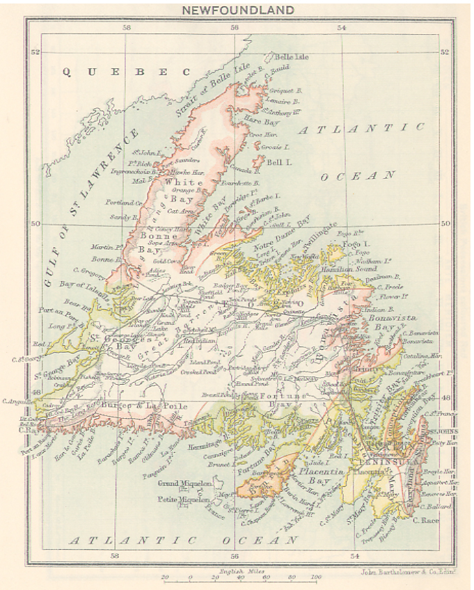
Map of the Island of Newfoundland, 1900
Climate and vegetation.
The island has a marine climate much modified by the cold Labrador current, which sweeps down the east coast and then swings to the west along the south coast. This keeps the summer cool, and also lowers the winter temperatures considerably. Thus the range of mean temperatures at St. John's is 36 degrees Fahrenheit, from 59° in July to 23° in January. At Corner Brook the range is 44 degrees, which is high for a marine station. In January all the island is below freezing point, and even in summer snow persists in places on the elevated plateaux. In July most of the island is above or near 57°F., but the warmest region (61°F.) is in the west in the vicinity of Corner Brook. The rainfall is adequate, ranging from 30 inches on the north-west to 60 inches on the south coast. A very heavy snowfall (over 120 inches) is found in the north-east of the island, rivaled only by that north of the city of Quebec. Fogs are very prevalent on the south-east coasts.
There are only a few weather stations; but the natural vegetation gives a fair indication of the climate. About half the area is forested, but much of the higher land in the south and west consists of "moss barrens" which are of no value for pasture or timber. In accord with the temperature, ash and elm are confined to the warmer south-west valleys, while yellow birch and white pine are common in the centre and west. Balsam fir and black spruce are general everywhere in the lower lands except in the north-east, where aspen and paper birch stand the cold climate better.
Main industries.
The main industries of the island have to do with timber, fish, and minerals. In 1944 the relative values of these three commodities were 44, 18, and 8 million dollars. Agriculture plays a very small part; the principal farming districts are on the Avalon peninsula, near Bishop's Falls, along the Codroy valley, and to the northwest of Deer lake.
Mining has been carried on in various parts of the island, but only two large fields, Buchans and Wabana, are in operation at present.
Cod fishing, which accounts for about three-quarters of all fishing done, is carried on in the inshore fishery, based on the innumerable villages scattered around the coasts, and on the Newfoundland banks. The banks are large areas of sea floor (equaling the area of Newfoundland today) which lie to the south-east of the island under a shallow cover of ocean water. They are washed by the Labrador current, and carry large supplies of halibut, haddock, and herring, as well as cod. Herring are taken chiefly in the bays, especially near Corner Brook. Salmon are taken during the summer off the east coast, while lobsters are numerous in the shallow water close to the north-west coast.
The timber and paper industry, which accounts for approximately one half of the island's exports, by value, is carried on by two large companies which hold extensive limits along the coasts and river valleys.
Communication and Population.
The pattern of settlement until about 1896 - when the railway was completed - was unique for such a large island. Every village was on the rugged coast, and there was little or no land communication except in Avalon. However, numerous good harbours were available, so that. all communication was by sea. This is still the case with the vast majority of the settlements; which form a continuous fringe of tiny fishing villages all round the coast.
Labrador.
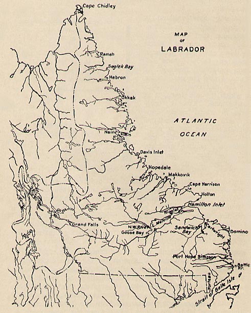
Map of Labrador, 1946
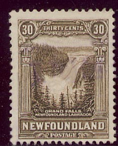
The huge territory of Labrador was finally allocated to Newfoundland in 1927. It comprises 110,000 square miles, but is almost uninhabited except along the coasts where some 5,000 people live. They are mostly Eskimos [now called Inuit] or Indians [mostly Innus] engaged in fishing and sealing. Port Hope Simpson (352) is one of the largest settlements. The whole area forms part of the Canadian Shield, and is built up mainly of granite of Precambrian age. The surface is undulating and studded with innumerable lakes amid the surface layers of glacial debris. The general level is well over 1,000 feet, the plateau being highest along the southern boundary of Labrador. However, in the extreme northeast are three higher areas, the Torngats, Kaumajets and Kiglapaits, which are remarkable for the prevalence of numerous cirques, which are armchair valleys cut out by glacial erosion. Some peaks in the Torngats rise over 5,000 feet. The main drainage is by the Hamilton river [now called Churchill] which rises in a number of lakes near the western boundary. It drops from the plateau into a deep gorge at Grand falls - where it is stated that one and a half million horse power may some day be available. It enters an enclosed basin, Lake Melville, on which is situated Goose Bay airport, one of the largest on the continent.
 The
climate is bleak and cold along the coast - so that tundra vegetation reaches
south to Hamilton inlet. Inland there are fair forests, especially in the lowlands
of Hamilton river. Fur trapping engages the attention of a few hundred Indians
in the interior. The chief economic interest centres in the huge reserves of
iron ore on the divide between the Hamilton and Kaniapiskau rivers. It is proposed
to exploit this ore by a 300 mile railway southward along the Moisie river to
a port at Seven Isles [Sept
Iles] in the Gulf
of St. Lawrence.
Bibliography.
B. V. Gutsell, Geography of Newfoundland (Dept. of mines, Ottawa, 1949) ; R. A. MacKay (ed.), Newfoundland: economic, diplomatic, and strategic survey (Toronto, 1946) ; V. Tanner, Newfoundland-Labrador (Cambridge, 1947); Griffith Taylor, Newfoundland settlement (Toronto, 1946) and Canada (London, 1947); A. K. Snelgrove, Geology of the central mineral belt of Newfoundland (Montreal, 1929). [Consult the extensive collection of maps of Newfoundland found at the Newfoundland Heritage site. The same site also has a large collection of historical maps of Newfoundland]
Source: Griffith TAYLOR, "Geography", in W. Stewart WALLACE, ed., The Encyclopedia of Canada. Newfoundland Supplement, Toronto, University Associates of Canada, 1949, 104p., pp. 29-33. The maps of the original text, as well as reference to them in the text, have been deleted. The Newfoundland map reproduced in this article is from J. Castell HOPKINS, ed., Canada. An Encyclopedia of the Country, Vol. V, Toronto, The Linscott Publishing Company, 542p., p. 16f. The Labrador map is from W. B. TEMPLE and L. J. HARNUM, Information Booklet of Newfoundland and Labrador, Compiled for the Newfoundland Industrial Development Board, St. John's, 1946, 120p., p. 6.
© 2004 Claude Bélanger, Marianopolis College |