Maps of Quebec / Cartes
du Québec
Last
revised:
20
August 2004
|
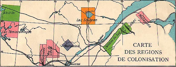
Map
of the Colonization Regions of Quebec
Carte des régions de colonisation de la province
de
Québec
1923
The 1923 Atlas-géographie
of primary schools of the Frères Maristes of the province
of Quebec asked the question: "Is the territory of the Province of Quebec
entirely colonized?" The answer provided was that "the province had
barely one twentieth of its territory colonized, cleared and organized
into municipalities; more than 15,000,000 acres of good fertile land
were waiting to be tilled; that is why the provincial government was
doing everything within its power to promote farming". Further, the
same text assured the pupils that "those who left the province for the
United States would do much better to go instead to one of
the regions of colonization chosen by the provincial government; there,
they would find more rapidly and more easily a modest affluence, independence
and freedom since the peasant who owns the land he cultivates is like
a small king on his domain ".
The colonization areas were (as
described by the Atlas ):
- Abitibi : the new transcontinental line of the Canadian
National Railway (CNR) had opened opportunities. [The region was excellent
for mining; a short growing season limited agricultural development.]
- Lake Temiscaming : flat lands around the lake and a micro
climate made agriculture possible, especially the dairy industry although
markets were far.
- The valleys of the Gatineau and the Lièvre
rivers: these sub regions of the Ottawa Valley contained flat
land close to the rivers. Good forest reserves permitted lumbering.
Inevitably, the "industrie agro-forestière" developed in this
setting.
- The basin of the river Matawin : The Atlas of
1923 declared this valley to be one of the most fertile in the province.
- Lac St.-Jean : "whose soil is of an inexhaustible fertility"
according to the Atlas .
- The townships of south-east Quebec : alongside the transcontinental
line of the CNR "parishes are springing-up as if by magic".
- The Valley of the Matapedia: "a magnificent agricultural region
capable of sustaining 400,000 souls".
While these regions clearly offered some opportunities, it is evident
that the editors of the Atlas greatly overestimated their potential.
They evidently suffered from agriculturalism.
Source of the map: Les Frères
Maristes, Atlas-Géographie. Étude physique - Politique,
Économique du Canada et de la Province de Québec ,
Montreal, Granger Frères Ltée, 1930 [1923], p. 49
© 2004
Claude Bélanger, Marianopolis College
|