|
|
| Date Published: |
L’Encyclopédie de l’histoire du Québec / The Quebec History Encyclopedia
Geography of Canada
[The text was written by William L. Grant in 1948. For full citation see the end of the document. Parts in brackets [.], images and links have been added to the original text by Claude Bélanger.]
The Dominion of Canada comprises the whole northern half of the North American continent except the United States territory of Alaska, and Labrador [Labrador was added to Canada in 1949, following the Union of Newfoundland with Canada], a dependency of the colony of Newfoundland. It also includes all the large islands off the coast [including] Newfoundland , and the Arctic archipelago between Davis strait and the 141st meridian.
The main features of the physical geography of Canada are those of the whole continent. The western half of North America , geologically the most recent, is uniform from north to south. A great central plain stretches from the Arctic ocean to the gulf of Mexico, with a very moderate watershed near the southern boundary of Canada . Between the great plain and the Pacific ocean rises a broad mountain belt, the North American Cordillera, unbroken from one end to the other. In Canada the parallel ranges constituting this mountain chain are closer together than they are further south, so that the valleys between are contracted, and the most westerly range is partially submerged, being represented by a fringe of mountainous islands along the coast. In the eastern half of the continent there has been a different process of development. Most of eastern Canada is occupied by what is called the Archaean shield or protaxis, the nucleus of the entire continent, perhaps the oldest land now visible above the oceans. As the name implies, it is a shield-shaped or roughly triangular plateau of very ancient rocks, with a surface highly irregular, in the centre of which a great depression is filled by the waters of Hudson bay. It extends to the Arctic and Atlantic oceans on the north and north-east; its south-eastern edge bounds the valley-plain of the St. Lawrence river and estuary; and its south-western and western limit is marked by a series of great lakes, Huron, Superior, Winnipeg, Athabaska, Great Slave lake, and Great Bear lake, beyond which lies the great plain. A deep cleavage south of the Archaean shield, occupied by the valley of the southern chain of great lakes and their effluent, the St. Lawrence river and estuary, divides the eastern half of the continent, the southern portion having no structural correspondence with the northern. The Appalachian mountain region south of the St. Lawrence valley is, however, represented in Canada by its northern extremity, constituting the provinces of Nova Scotia and New Brunswick and the Gaspé peninsula in the province of Quebec, but these lie wholly south of the cleft of the St. Lawrence. The great natural divisions of Canada are, therefore, from west to east, the Cordillera or mountain region, the great plain, the Archaean plateau, the valley-plain of the Great lakes and St. Lawrence, and farthest east, the tip of the Appalachian plateau. Another division is constituted by the Arctic archipelago, which is not a part of the Archaean shield, but its structure is not yet fully known. North America , like the other continental masses, has developed its greatest breadth towards the north, becoming narrower further south and tapering almost to a point at the southern extremity. The greatest breadth of the continent is thus found in Canada, where along the 52nd parallel of latitude a continuous land surface, interrupted only by the south end of James bay, extends for about 3,400 miles [5480 km] from the coast of Labrador to that of British Columbia.
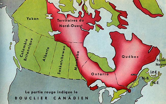
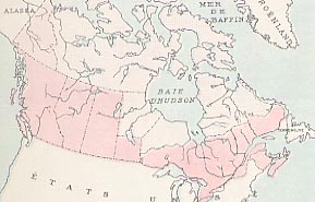
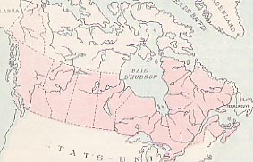
Extent of the Canadian Shield in red (This map is extracted from a textbook current in Quebec in the 1950's. It is somewhat inaccurate as the Canadian Shield extends much more deeply into Saskatchewan than is shown here. For a more recent map, consult the relevant article of the Canadian Encyclopedia.)
Area and Boundaries . The area of the Dominion (as revised on the basis of the results of recent explorations in the north) is 3,684,463 square miles, a figure which may be compared with that of 3,738,395 square miles for the United States and its dependent territories, 3,776,700 for the total area of Europe, 2,974,581 for Australia, 3,275,510 for Brazil, 1,805,332 for India, 121,633 for the area of the British Isles, and 13,355,426 for the British Empire.
The Dominion is bounded on the west by the Pacific ocean and Alaska; on the south by the 49th parallel, the Great lakes, the St. Lawrence river and additional lines set out by the Ashburton Treaty, signed between Great Britain and the United States on August 9, 1842; on the east by the Atlantic ocean, the gulf of St: Lawrence, the territory of the coast of Labrador, and Davis strait. To the north, Canada includes all the lands in the area bounded on the east by a line passing midway between Greenland and Baffin, Devon and Ellesmere islands to the 60th meridian of longitude, following this longitude to the pole. The southernmost point is Middle island in lake Erie, in north latitude 41° 41', while from east to west the Dominion extends from about west longitude 57° - at the southernmost point of the boundary with the coast of Labrador - to west longitude 141°, the boundary with Alaska.
On the north Canada thus stretches to the North Pole. The search for the North West Passage is one of the great stories in the history of exploration, and in the northern archipelago the names of every sound, channel, strait, island and bay recall heroic deeds. Most of them are part of the glory of the British race, but when in 1903-6 the first explorer passed from the Atlantic to the Pacific in a single ship, the deed was that of Amundsen, an heroic Norwegian. The western boundary is on the south the Pacific ocean, but from a little north of the town of Prince Rupert , Canada is cut off from the ocean by the panhandle of Alaska up to mount St. Elias, whence the boundary runs along the meridian of 141° to the Arctic ocean . This is one of the many triumphs in Canada of history over geography. In the late 18th and early 19th centuries Russian fur-traders occupied Alaska and crept steadily down the coast in order to trade with the natives at the heads of the inlets. Thus, when in 1867 the United States bought Alaska from Russia , she took over the best harbours on the northern Pacific.
On the east also, much of the north of Canada is cut off from the sea by the award of the Privy Council of March 1, 1927. The Newfoundland fishermen had long occupied the coast of Labrador , and by a decision based much more on historical pedantry than on commonsense great portions of the inland territory have been handed over to the government of an island which has neither the resources nor the population for their development. [This section is now redundant since the union of Newfoundland with Canada was effected in 1949]
The southern frontier runs mainly along the line of the St. Lawrence river and the Great lakes, and further west along the 49th parallel; but both at the eastern and western extremities historical conditions brought Great Britain and the United States to the verge of war before the frontier was delimited. (See Ashburton Treaty and Oregon question.)
Climate and Rainfall . Climate, or seasonal variation of heat and cold, is conditioned by two main factors, latitude and distance from warm oceans. The varied relief of the land in mountains, high plateaus, and low-lying plains or valleys, is an additional factor of special importance locally. The northern situation of Canada as a whole implies severe winter cold except where a near-lying ocean may exert a moderating influence. This influence is found along the western coast, where the warm moist air from the north Pacific current sweeps over the whole Cordilleran region, and in the most northern part, where the mountain ranges are lower, even penetrates beyond them as far as the valley of the Mackenzie river. An abundant rainfall accompanies the passage of the warm air, producing rich vegetation on the western slopes of the mountain ranges. The Arctic ocean being largely covered with ice-floes in winter is negligible as a factor in the climate of its coasts, as is also Hudson bay , except for a moderate distance from its shores. On the east the Atlantic along the coast of Labrador is a cold body of water, and has little effect on the climate of the peninsula, but further south the warm current known as the Gulf Stream is not far away from Nova Scotia, New Brunswick, and Prince Edward Island, and these provinces in consequence have a milder winter than their latitude would imply. The valley of the St. Lawrence is also to some extent affected by the proximity of the Atlantic, and southern Ontario , partly on account of its projection into lower latitudes, partly from the ameliorating influence of the Great lakes which surround it, enjoys a temperate climate without extremes either of heat or cold. All these eastern provinces have an abundant rainfall, sufficient for the growth of fine timber as well as for agriculture. The provinces of the great plain, far from oceans and wholly north of latitude 49°, are subject to extremes of heat in summer and cold in winter. The amount of precipitation, whether snow or rain, is sufficient for agriculture except in the extreme south of Saskatchewan and Alberta , where semi-arid areas are found. But the southern part of the great plain is without trees except along the courses of rivers and streams. Further north in all the three prairie provinces a low growth of soft-wood trees begins, and extends to form a wide belt of northern forest, becoming more stunted as it reaches northward, until it disappears and gives place to the vast tundra, known as the Barren Lands, which stretches to the Arctic coast.
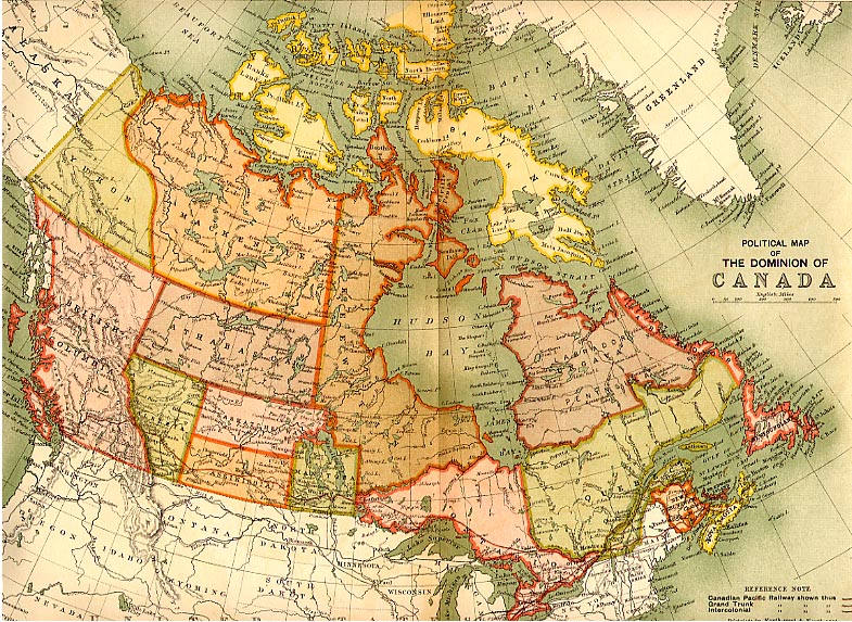
Political map of Canada, 1898, with provinces and territorial districts outlined
Lack of Unity . From this description it is obvious that much of Canada lies so far to the north that it can never support a large population. The isothermic map shows, however, that along the Peace river and as far north as Great Slave lake the long hot days enable wheat to be grown and farming to be carried on, even though the summer is comparatively short. The total land area of the nine provinces [now 10 provinces] is estimated at 1,309,724,800 acres. Of this total area approximately 358,162,190 acres are fit for agricultural settlement, of which at present about 141,000,000 are occupied.
In a very real sense Canada is an artificial country, bound together by railways. A glance at the map shows how artificial is the frontier between Canada and the United States , and the previous paragraphs show how little natural unity there is between the various parts of the country. In 1891 Canada was described as "four separate projections of the cultivable and habitable part of the continent into Arctic waste . . . . these blocks of territory are not contiguous, but are divided from each other by great barriers of nature" ( Goldwin Smith, Canada and the Canadian question, 1891).
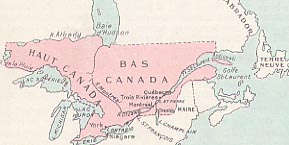
The first settlements which grew up in the valley of the St. Lawrence were French, and formed a nucleus, to which after the American revolution was added a large accretion of Loyalists in Upper Canada (now Ontario ). In the nineteenth century the natural increase, especially of the French, and a considerable immigration, raised the population of this central area to over 2,500,000; but it was cut off from the sea for five months of the year. Confederation in 1867 added Nova Scotia and New Brunswick. Of these the former was inhabited mainly by descendants of English and Scotch settlers, the latter by Loyalists. They had harbours open the year around, and the Intercolonial Railway, which unites them to the central core, was deemed to be so important that a promise of its construction was made a part of the British North America Act [now called the Constitution Act, 1867], which gave legal sanction to the federation. But though the railway unites the St. Lawrence basin to the Atlantic, between the Maritime provinces and the settled part of Quebec there still juts up a great area of rock and river and forest, the paradise of sportsmen, but ill-fitted for a resident population.
Sault Ste. Marie, at the junction of lake Superior and lake Huron, marks the limit of western settlement in the St. Lawrence basin, and from here to Winnipeg, a distance of at least 800 miles, there is little settlement in the tumbled rock, lake, and forest of the Canadian Shield, save at the head of lake Superior, where the shipping towns of Port Arthur and Fort William [now Thunder Bay] have grown up to trans-ship the western grain crop. The barrier thrown by the Rocky mountains between the Pacific coast and the prairies is plain to the eye.
Yet to a large extent man has conquered nature. Through these apparent waste stretches oases of settlement have sprung up; here a mining camp; there a fertile patch of land; here the needs of the tourist have attracted permanent settlement. In older countries the railways follow settlement; in North America they precede and allure it. The Intercolonial and the Canadian Pacific Railways bound Canada together. Settlement grew up along them, and their numerous branches. The Canadian National gives also a certain solidity. Canada is now finding the maintenance of her railways a burden; that there was extravagance of construction is certain; but in the main the burden is the price which she pays for her unity.
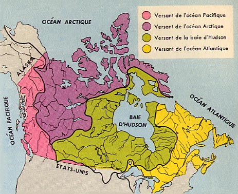
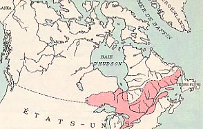
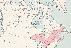
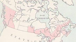
Lakes and Rivers . Such natural unity as Canada has is given by rivers and waterways. The Canadian rivers which flow into the Atlantic north of the boundary are estimated to drain 525,000 square miles; those into the Arctic 1,300,000 square miles; those into Hudson bay 1,500,000 square miles, and those into the Pacific 320,000 square miles. The total area of the country drained by rivers which reach the sea south of the boundary is less than 100,000 square miles. [See drainage basins]
Hydrographic
basins in Canada. The Pacific basin is in pink, the Arctic basin is
in violet, As a result of her geological structure, all Canada , save the prairies, is lavishly strewn with lakes of all sizes, from bodies of water hundreds of miles long and a thousand feet deep to ponds lost to sight in the forest. The largest and most thickly strewn lakes occur within five hundred or a thousand miles of Hudson bay , and belong to the Archaean protaxis or project beyond its edges into the Palaeozoic sedimentary rocks which lean against it. The most famous are those of the St. Lawrence system; but many others have from their magnitude the right to be called " Great Lakes ".
Lake Superior (31,810 square miles in area and over 1,000 feet deep) is the largest body of fresh water in the world. Lake Huron has an area of 23,010 square miles; Great Bear lake of 12,200 square miles and Great Slave lake of 11,170 square miles. Within the Archaean protaxis the lakes are of the most varied shapes and sizes, since they represent merely portions of the irregular surface inundated by some morainic dam at the lowest point. They often contain islands, sometimes even thousands in number, as in Georgian bay and Lake of the Woods. Of the rivers the St. Lawrence is 1,900 miles in length, the Nelson 1,600, the Saskatchewan 1,200, the Churchill 1,000, the Mackenzie 2,514, and the Peace 1,054. From one system to another and from one part of one system to another the distances are short, and the watersheds low, and it is usually possible to go by portage. In the early days of Canada, when the fur-trade was one of her great sources of prosperity, the voyageurs [or coureurs de bois] went from Montreal to the Rockies in their canoes, and some of these portages, such as Grand Portage, the gateway from lake Superior to the west and northwest [see the Boundary Waters-Voyageurs Waterways], and Methye Portage from the Churchill and the Saskatchewan to the Mackenzie system, were long famous.
The same geological structure makes Canada peculiarly rich in water-power both in the Laurentian and in the Cordilleran areas, and has greatly aided in her manufacturing development. Coal is found chiefly on the extreme east and west; but the waterways enable it to be carried for long distances; and with this and her water-power she has reached a height of manufacturing development, and therefore of the comforts and complexities of city life, which contrasts very sharply with the Christmas card pictures of "Our Lady of the Snows".
She is thus bound together by waterways and railways, and her northern frontier is the northern fringe of habitable land. Canada in 1867 stopped at lake Huron. In 1869-70 she purchased the vast territories of the Hudson's Bay Company, and in 1871 she was joined by British Columbia. This gave her a frontier on either ocean, but she could still be described as "a bundle of fishing rods tied together at the ends". Since then man has steadily triumphed over nature, and her habitable areas have extended northward till now her populated territory might be described as representing a wasp with its waist at Winnipeg. The aeroplane is supplementing the work of the steam-engine. Mining is being carried on at Great Bear lake, and the surface has only yet been scratched. Year by year new areas yield to man's daring and man's science.
At the same time, it is almost certainly true that had it not been for her history, and more especially for the early French settlements, she would today be part of the United States. The French settlements in and about Quebec and Montreal, which had fallen into British hands in 1763 gave her a nucleus around which the Loyalists could settle twenty years later after the American revolution. Had it not been for the French and the Loyalists the expansion of the United States would have swallowed up British North America, as it did Louisiana, Russian North America, and large slices of Spanish North America. It is true that through the Hudson's Bay Company Great Britain very early had extensive trading interests in the west, and that on at least one occasion she risked for these war with the United States. But certainly had it not been for the early French settlement and the Loyalist accretions, Canada as a nation would not exist as it does today.
Territorial
Evolution of Canada
|
© 2004
Claude Bélanger, Marianopolis College |
|